Piecing the Fragments Together – a new history of Shrawley Parish 1066-1603
Updates
(as of 25th October 2026)
Should you wish, the following content is available in pdf format.
Click here.
A book like this is never finished. The research continues and further insights – both corrections and additions – are to be expected. To cope with this, updates and corrections will be posted here on the Shrawley History Website.
And despite care taken to check the contents before the book was printed, errors of format and data have crept in. So far I have recognised the following, but there will be others…
ERRATA
p23. The Modus
The 1836 Act for the commutation of tithes in England and Wales consolidated a trend that had been ongoing since the 18th century, converting the old tithes (a tenth of all produce in the parish) to a monetary equivalent. The old term modus decimandi or modus in English was an earlier commutation following the same principle, a monetary equivalent for tithes that were difficult to collect in kind. The massive industrial production of fuelwood from Shrawley Wood to supply the salt boileries in Droitwich was probably one of the earliest modi ever to be agreed: it would have been quite impossible for the rector of Shrawley to collect (and then process and sell) one tenth of each year’s fall – all the wood felled, be it for burning or building. So a monetary equivalent was agreed – £3 4s 0d representing a tenth of the estimated sales revenue of £32. In 1120 this was a massive sum, greater than the sum of all the other revenue from the parish including the fish weir, the mill, the meadows, the arable crops, the livestock increase and the rents. Over the years inflation, rapid during Henry VIII’s reign, reduced the value of this modus compared to the real revenue from the wood. But the modus was legally fixed and essentially unalterable and remained the same £3 4s 0d until 1839, when a new modus was signed off for Shrawley Wood. Its value was set at £5 0s 4d – a minimal increase seeing that the real revenue from the wood was then around £400 per annum, with labour costs of around £100. The modus should have been around £30 but the Commissioners were not allowed to introduce such a massive increase in a modus that had been constant since antiquity, defined as before 1189 in the case of legal arguments about a modus. When I first wrote the section on the modus I mistakenly used the 1841 value; this despite having previously published the modus of £3 4s 0d recorded in the Reverend Daniel Piercy’s tithe notebook.
So apologies – this section should have read:
The Modus
The Reverend Daniel Piercy’s tithe notebook records a modus for the wood of £3 4s 0d. This was a fixed payment in lieu of a tenth of produce, and therefore implies an annual revenue of £32 from the sale of wood. The question is when this modus decimandi was first established. Although the documentary trail is discontinuous, there is good reason to suppose that its origin was ancient.
It seems doubtful that Urse d’Abitot would have concerned himself with paying tithes, but he died c. 1108. Once the Beauchamps became overlords of the d’Abitot lands, they appear to have taken immediate steps to establish a benefice for the Shrawley priest (see the chapter on the Stone Church). The scale of the wood sales makes it highly unlikely that the priest of Shrawley ever handled the wood directly: bulk firewood sales were a specialised trade, not a clerical occupation, and a modus was the obvious means of giving the priest a stable income without interfering with operations in the wood. The establishment of such a modus would have required a legally binding agreement between lord and church, and the figure of £3 4s 0d would have resulted from agreement that the typical annual sales value of the wood at that time was £32. This is a realistic amount in view of the demand for firewood for Droitwich but greater than the sum of all the other revenue from the parish including the fish weir, the mill, the meadows, the arable crops, the livestock increase and the rents, and it would have made the Shrawley benefice particularly attractive. If these arguments are close to the truth, the modus must have been settled soon after 1110.
Such a legally defined modus was notoriously difficult to alter, and a modus generally remained constant in the face of inflation. By 1390 the woodmen were purchasing the licence to cut the coppice and an agreed quantity of oak each year, with payment delayed until the proceeds of sale had been realised. The minister’s account for 1539 confirms that the sale of underwood was a customary practice “since antiquity”, and that the tenants – not the priest – were responsible for selling the fall. If the mean annual revenue from the wood was reckoned at £32 in 1230, the sales revenue in 1390 was likely greater, and by 1545 certainly was. The licence fee paid by the woodmen ranged between £6 and £12 (with a mean of about £8), so the modus of £3 4s 0d would have left an annual balance of roughly £24 at 1230 prices, but substantially more by 1545, the last year the woodmen could follow this old system.
From this the woodmen met their labour costs and divided the remainder among the four to six men involved; even after expenses, each would have retained well over £3 – probably more than £5 – a year. Given that they also held agricultural land, this provided the basis for a comfortable living and explains how they were able to accumulate property over time.
p59. Missing Caption
The caption for illustration 07 had slipped onto the next page.
p61. Holt not Hope
My mental cogs must have slipped here, when I wrote Hope instead of Holt three time in the 4th paragraph in the first column.
p84. Bovrugge
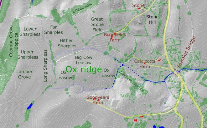
In the chapter Tenants of the 15th century, for Roger Baker the existing text suggests bov’rugge might indicate the bridge on the track to Cock Thrum (Wood Farm). This turns out to be wrong. (See the chapter on Mapping Early Shrawley: additional material below). Bov’rugge should translate as Ox Ridge.
p107. Addendum
Cobblers Lane
In the summer court of 1587: And the 12 Jurors are required to inspect the lane called Cobblers Lane whether it is a common way to the fundus [tenement with land] called le Bond Fyldes or not. And this before the feast of St James Apostle.
In the next court, autumn 1587: A penalty is imposed on Thomas Hampton and the widow Charistian Severn nor others in their name not to drive their <cattle> or carts along the lane called Cobblers Lane as far as Band Land imposed under pain for each offence 20s.
This follow-up item suggests the lane was a common way otherwise the offenders would have been amerced for trespass. It seems that the area of Bonefields Farm was called Bond Fields or Band Land in the 16th century.
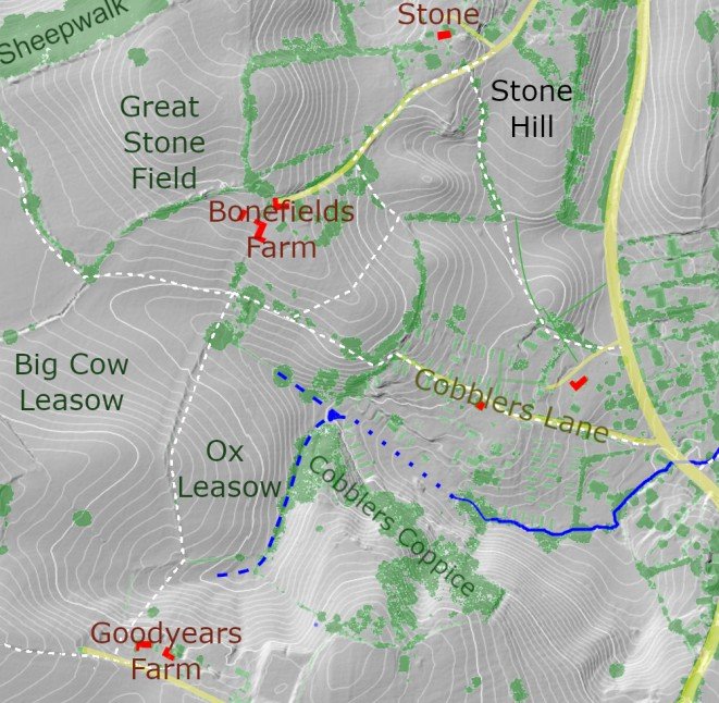
I have checked the spelling in the original rolls for these items and it clearly says Bond Fyldes and Band Land; both must surely be referring to Bonefields. “A common way” meant much the same as a public right of way. It seems that among her many other sins, Christian Severn had been churning up the surface of the lane. This remains a public right of way even today.
Bonefields may have started out as Bundes Field, Bunda/Buna/Bonda being a personal name. This might be reckoned more likely that previously proposed alternatives, based on bones or bon as in good.
p 138 Addition to the chapter Mapping Early Shrawley
Fyggys/Fydys Lak
Lak: Shrawley records of Fyggys Lak indicate that this was a watercourse with associated pools, bridges, culverts and drainage features; a managed ditch or channel that required regular clearance. Significantly, none of the other Shrawley ditches were designated Lak. But while this name included a small lake in Bartlam House grounds, it seems to have applied to the whole waterway; the item from January 1552 makes it clear that a lacus was not simply the lake. Taken together with all other records it is now possible to identify the exact location of this water course, and this in turn helps pin down the location of neighbouring tenements.
Spring 1406: And that the ditch below Clerkes feld has not been scoured by defect of John Nicolles <2d>
Autumn 1421: Presented that the ditch by Fygys Brugge not cleared by default of Thomas Hilhampton
Autumn 1480: Also that the ditch by Fygonis Brugge has deteriorated at the fault of Hugh Herbache and must be mended by next court under penalty of 12d.
Spring 1483: Homage there presented that Thomas Stacey kept 1 ditch blocked not drained next to Hopers Close also demanded the same Thomas must clear the said ditch by next St John Baptist under pain of 10s.
Autumn 1505: Also present that Thomas Sargeant and Thomas Trowell are in defect …[scouring] 2 ditches 1 at the end of his close and the other by Hopers Croft they are required to scour said ditches before the next court under penalty for both of them 20d
Spring 1518: Also present… nor has John Butler <4d> amended his ditch by opers close [Hoopers Close?] as they had been required to do so they have incurred a penalty
Autumn 1529: Also present that John Bartlam <2d> has incurred a penalty because he has not made the road called Fyggelake as he was ordered to so he is in mercy
Autumn 1546: Also require John Clark to scour his ditch by Dey Hill by his close before the next feast of St Michael under pain of 3s 4d
January 1552: And require Thomas Marten and John Clarke sufficiently scour a lacus by Fyggys lake before next feast aforesaid [St Matthew Apostle] under pain of 40d. And require that Thomas a Sevarne <Jr. > and John Clarke scour the ditch by Greyhey before the Feast of St Matthew Apostle next under pain of 3s 4d
Spring 1565: Furthermore John Clerke is required to scour his ditch at Fygge Lake before Pentecost under pain of 5s. Also a penalty is imposed on the widow Margaret Clerke to scour her ditch by le Greyheys from le Cornell de la Stokynge as far as her house before Easter under pain of 2s.
Autumn 1566: Similarly John Clarke incurs a penalty of 4d because he has not properly scoured the ditch at Figgis lak [apud Figgis lakam] as he has incurred the penalty
Autumn 1566: Similarly it is required of John Clarke to make a style at the further end of Fyggis Lak [written in mixed English and latin: le style apud le further end de Fygge lake] well and properly leading to the church for Thomas Bartlam before Christmas under pain of 20d
December 1577: They also present that Johanna Severn loses the penalty of 3s 4d because she has not scoured the ditch around Whopers Close as she had in penalty however by the grace of the court this was affeered at 12d and furthermore she is required to well and truly scour the ditch around the aforesaid close before the Annunciation of Blessed Mary [25 March] under pain of 6s 8d
Autumn 1590: And it is required that the 12 sworn inspect at Fydys Lacke the road encroachment there between William Yerran’ and Richard Stone before the feast of All Saints under pain of 3s 4d.
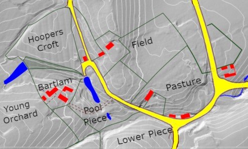
The 1529 reference to “the road called Fyggelake” probably refers to a short curved road shown on the 1839 tithe map running to a pond on the course of Fyggys Lak below Spring Cottage. The road may have provided access to water for livestock.
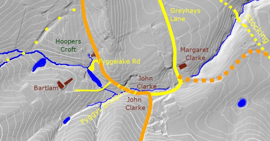
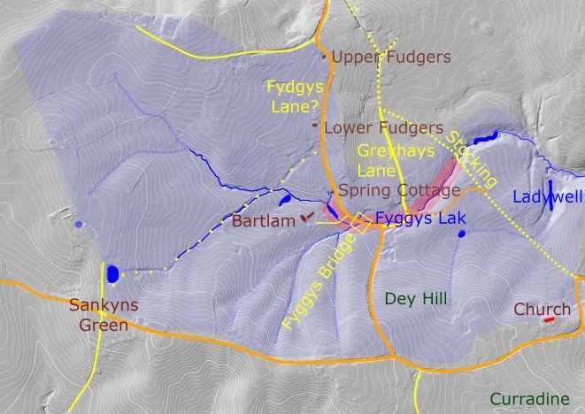
Reference to Fyggys bridge most likely refers to the bridge where the old Kings Way crossed Fyggys Lak rather than one of the four other bridges (to Herbache where John Bartlam lived, to Greyhays Lane, a later bridge for the new connecting road between the Stocking and Greyhays lane (orange dots) and one for the path called the Stocking.
The earliest attested element of the name is Fygys Bridge, recorded in 1421 in a lost roll recorded in Prattinton’s notes. Later records refer to Fyggys Lak, a managed watercourse requiring regular maintenance, and to the road called Fyggelake. This sequence suggests that the bridge-name became attached to adjacent landscape features, including the drainage channel and the road crossing it. The later tenement names Upper and Lower Fudgers may represent a subsequent development of the same local place-name, preserved long after its original meaning had been forgotten.
The Stocking (04) may have taken that name as a staked boundary path between the eastern and northern thegnlands, marking the edge of the pastoral infield, originally all the way down to the church way. I deduce that the later road improvement used the southern part of this when it built a new road to link to Greyhays Lane. The Stocking is still used as the name for the footpath following that route.
Tybot’s Ditch, Sewales Bridge and Shewell’s Waterway
In a lost court roll of 1408 – preserved only through Peter Prattinton’s 1829 transcript – the homage presented that “the way next to Sewales Bridge had deteriorated through flow from Bov’rugge by defect of Roger Baker.” Sewales Bridge almost certainly refers to the crossing over the Shewell watercourse whose position is later fixed by the 1578 dispute between William Thrupp and John Stone of Astley (see Tenants of the Sixteenth Century). The place‑name Bov’rugge now seems straightforward: rugge is Middle English for a ridge, while bov’ is the Latin bovinus, “ox” or “cow.” The compound therefore means Ox Ridge or Cow Ridge. This identification is confirmed by the 1839 tithe map, which names the same area Big Cow Leasowe and Ox Leasowe, preserving the medieval cattle‑pasture sense of Bov’rugge. The 1408 entry thus records water damage caused by runoff descending from the cattle ridge into the Shewell crossing, for which Roger Baker was held responsible.
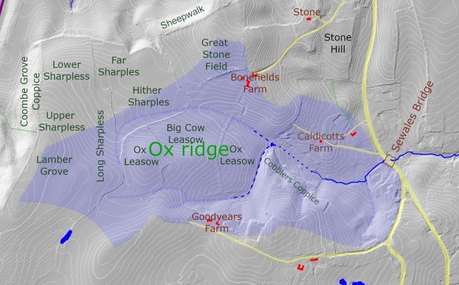
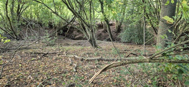
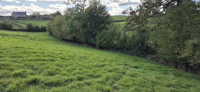
The limb of this ditch below Ox Leasowe is now called Little Beck by Elaine Fellows of Caldicott’s, to whom I am very grateful for her help in understanding this landscape. The section of ditch through part of Caldicott’s has been piped in recent years (dotted) and carries no water in summer (dashed line).